Back to Main Menu
Account Menu
no reviews for this product. Login to place a review.
The Garmin California to Mexico BlueChart g2 Vision Chart provides precise, on-chart position of a vessel in relation to navaids, coastal features, anchorages and other marine landmarks with smooth displays and seamless zoom transitions. It has 2D and 3D perspectives for user ease and can load route plans from a computer when used with HomePort software (sold separately). It also features Auto Guidance technology that searches chart data for the ideal passage to a destination, MarinerEye birds eye 3D viewing, FishEye underwater 3D viewing and provides high resolution satellite imagery with real world photos. The mapping data is available on a microSD card.
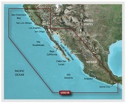
The map covers Point Arena to Puerto Vallarta, including Mendocino, San Francisco Bay, Channel Islands, San Diego, Baja California.