Back to Main Menu
Account Menu
no reviews for this product. Login to place a review.
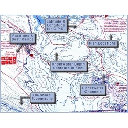
Fish-N-Map Underwater Topography Maps for Idaho provide extensive and detailed legends that provide fishermen and boaters with a variety of information. They are printed on water-proof, tear-resistant plastic and fold down from 3'x2' when open to 9"x4". Most maps are double sided.
| ITEM # | LOCATION | GPS | CONTOURS | SCALE | WATER< /th> | NOTES |
|---|---|---|---|---|---|---|
| FNM092151 | Brownlee Reservoir | Yes | 20 | 1:24,000 | Fresh | |
| FNM009210 | Coeur d Alene Lake Priest Lake | Yes | 15 | 1:15,500 1:37,730 | Fresh | |
| FNM092137 | Snake River | Yes | 1:50,000 | Fresh | Ice Harbor Dam, WA to Lewiston, ID | |
| FNM092106 | Pend Oreille Lake | Yes | 5 | 1:33,330 1:44,440 | Fresh | |
| FNM092168 | CJ Strike Reservoir | Yes | 10 | 1:17,800 | Fresh | |
| FNM092199 | Dworshak Reservoir | Yes | 40 | 1:24,000 | Fresh |