Back to Main Menu
Account Menu
no reviews for this product. Login to place a review.
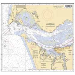
The Evergreen Pacific 18" x 20" Columbia River Chart is a reduced size lithographic reproduction of the mouth of the Columbia River NOAA Chart 18521. It includes the mouth of the Columbia River from Cape Disappointment and Clatsop Spit to Taylor Sands. This map is printed on waterproof paper, making it durable for everyday use or can be framed as a functional piece of artwork.
