Back to Main Menu
Account Menu
no reviews for this product. Login to place a review.
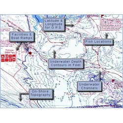
Fish-N-Map Underwater Topography Maps for Northern California provide extensive and detailed legends that provide fishermen and boaters with a variety of information. They are printed on water-proof, tear-resistant plastic and fold down from 3'x2' when open to 9"x4". Most maps are double sided.
| ITEM # | LOCATION | GPS | CONTOURS | SCALE | WATER | NOTES |
|---|---|---|---|---|---|---|
| FNM040015 | CA Lake Maps Atlas | Yes | Fresh | 50 Topography lakes, reservoirs and The Delta | ||
| FNM082657 | Camanche Folsom | Yes | 10 & 20 | 1:17,500 1:19,400 | Fresh | |
| FNM082640 | Clear Lake Berryessa | Yes | 3 & 20 | 1:34,500 1:28,700 | Fresh | |
| FNM082688 | The Delta | Yes | 10 | 1:65,500 1:20,000 1:100,000 | Both | Suisun Bay, Sacramento R., San Joaquin R. |
| FNM082664 | Don Pedro Pardee New Hogan | Yes | 20 | 1:21,900 1:24,200 1:24,400 | Fresh | |
| FNM082763 | Feather R. American R. | Yes | 1:40,000 1:40,000 | Fresh | ||
| FNM081278 | Golden Gate Offshore | Yes | 10 | 1:135,000 1:50,000 1:57,500 | Salt | Bodega Bay to Pt. Sur |
| FNM052070 | Lake Pleasant Lee's Ferry | Yes | 10 | 1:16,000 1:24,360 | Fresh | |
| FNM082633 | Lake Shasta | Yes | 20 | 1:23,000 | Fresh | |
| FNM82671 | Lake Orville San Luis | Yes | 10 & 20 | 1:25,900 1:27:250 |