Back to Main Menu
Account Menu
no reviews for this product. Login to place a review.
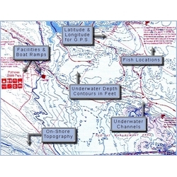
Fish-N-Map Underwater Topography Maps for Arizona provide extensive and detailed legends that provide fishermen and boaters with a variety of information. They are printed on water-proof, tear-resistant plastic and fold down from 3'x2' when open to 9"x4". Most maps are double sided.
| ITEM # | LOCATION | GPS | CONTOURS | SCALE | WATER | NOTES |
|---|---|---|---|---|---|---|
| FNM052018 | Alamo San Carlos | No | 10' | 1:14,600, 1:22,500 | Fresh | |
| FNM052025 | Apache, Canyon, Saguaro | Yes | 10' | 1:19,200, 1:16,000, 1:16,000 | Fresh | |
| FNM052032 | Bartlett Horseshoe | Yes | 10 | 1:10,860, 1:15,700 | Fresh | |
| FNM032041 | Lake Havasu | Yes | 5' & 10' | 1:10,860, 1:15,700 | Fresh | Fish habitat enhancement info |
| FNM032058 | Lake Mead | Yes | 30' | 1:53,700 | Fresh | |
| FNM032065 | Lake Mohave | Yes | 10' | 1:27,900 | Fresh | |
| FNM052070 | Lake Pleasant, Lee's Ferry | Yes | 10' | 1:16,000 1:24,360 | Fresh | |
| FNM032089 | Lake Powell South | Yes | 20 & 80 | 1:48,000 | Fresh | Wahweap to Escalante Arm |
| FNM032553 | Lake Powell North | Yes | 20' & 80' | 1:48,000 | Fresh | Colorado R. to Escalante Arm |
| FNM042187 | Lower Colorado R. | No | None | 1:45,900 | Fresh | Arizona, Southern California |
| FNM052094 | Roosevelt Lake | Yes | 10' | 1:20,000 | Fresh | Arizona |
| FNM042187 | Lower Colorado R. | No | None | 1:45,900 | Fresh | Arizona, Southern California |

