Back to Main Menu
Account Menu
no reviews for this product. Login to place a review.
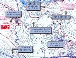
Fish-N-Map Underwater Topography Maps for Oregon provide extensive and detailed legends that provide fishermen and boaters with a variety of information. They are printed on water-proof, tear-resistant plastic and fold down from 3'x2' when open to 9"x4". Most maps are double sided.
| ITEM # | LOCATION | GPS | CONTOURS | SCALE | WATER | OTHER |
|---|---|---|---|---|---|---|
| FNM092144 | Lake Billy Chinook Simtustus | Yes | 20' | 1:16,000 | Fresh | |
| FNM092175 | Detroit Lake | Yes | 10' | 1:45,450 | Fresh | |
| FNM092120 | Willamette ClackamasSandy | Yes | 1:30,000 | Fresh | ||
| FNM092083 | Upper Columbia River | Yes | 10' | 1:45,450 | Fresh | McNary Dam to Bonneville Dam |
| FNM092090 | Lower Columbia River | Yes | 10' | 1:55,550 | Fresh | Bonneville Dam to the Pacific |


