Back to Main Menu
Account Menu
no reviews for this product. Login to place a review.
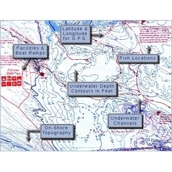
Fish-N-Map Underwater Topography Maps for Southern California provide extensive and detailed legends that provide fishermen and boaters with a variety of information. They are printed on water-proof, tear-resistant plastic and fold down from 3'x2' when open to 9"x4". Most maps are double sided.
| ITEM # | LOCATION | GPS | CONTOURS | SCALE | WATER | NOTES |
|---|---|---|---|---|---|---|
| FNM071167/071187 | Baja California South | No | 30 | 1:380,000 | Salt | Pt Eugenia to Cabo San Lucas (not included) |
| FNM071170 | Baja California North | Yes | 30 | 1:350,000 | Salt | Coronado Is to Pt Eugenia |
| FNM042125 | Castaic Piru Pyramid | Yes | 5 | 1:9,600 1:12,600 1:9,600 | Fresh | |
| FNM041180 | Catalina Island Long Beach | Yes | 30 | 1:60,000 1:125,000 | Salt | Dana Point to Santa Monica Bay |
| FNM041197 | Channel Islands Ventura | Yes | 30 | 1:25,000 1:20,000 | Fresh | |
| Diamond Valley | Partial | 10 | 1:12,000 | Fresh | Irvine Lake, Puddingstone | |
| FNM042149 | Hodges Sutherland Lake | No | 5 | 1:110,400 1:10,500 | Fresh | |
| FNM042170 | Isabella Big Bear | Yes | 2 & 10 | 1:20,300 1:14,000 | Fresh | |
| FNM041234 | L.A. and Orange Country Inshore Charts | Yes | 5 | 1:50,000 | Salt | Shoreline Pt. Dume to Dana Pt. |
| FNM081285 | Morro Bay | Yes | 5 | 1:58,400 |

