Back to Main Menu
Account Menu
no reviews for this product. Login to place a review.
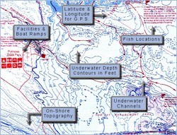
Fish-N-Map Underwater Topography Maps for Washington provide extensive and detailed legends that provide fishermen and boaters with a variety of information. They are printed on water-proof, tear-resistant plastic and fold down from 3'x2' when open to 9"x4". Most maps are double sided.
| ITEM # | LOCATION | GPS | CONTOURS | SCALE | WATER | NOTES |
|---|---|---|---|---|---|---|
| FNM091017 | Puget Sound South | Yes | 10 | 1:66,700 | Salt | |
| FNM091024 | Puget Sound North | Yes | 10 | 1:77,000 1:50,250 Inset 1 & 2 1:24,360 Inset 3 | Salt | Everett to Deception Pass |
| FNM092045 | Banks Lake Lake Washington | Yes | 5 | 1:26,000 1:35,700 | Fresh | |
| FNM092076 | FDR Lake | Yes | 10 | 1:60,600 | Fresh | Spokane River Arm |
| FNM092052 | Potholes Moses Lake Lake Sammamish | Yes | 5 & 10 | 1:25,800 1:34,200 1:24,360 | Fresh | |
| FNM092069 | Tri-Cities, Lake Wallula and Columbia River | No | 5 | 1:48,700 | Fresh | McNary Dam to Priest Rapids Dam |
| FNM092205 | Rufus Woods Cascade Lake | Yes | 1:28,900 1:28,200 | Fresh |


